The European Space Agency is to allocate EUR 80 million to the GENESIS mission, which goal is to do something that has never been achieved before in satellite and space exploration. The new satellite will help improve the accuracy of geodetic measurements on the Earth's surface. The team preparing the mission concept included four scientists from the Institute of Geodesy and Geoinformatics.
Three of the co-authors of the GENESIS mission concept are from Poland: Prof. Krzysztof Sośnica, Dr. Radosław Zajdel and Dr. Grzegorz Bury, while the mission advisory team also included Dr. Dariusz Strugarek. They are all from the Institute of Geodesy and Geoinformatics at the UPWr.
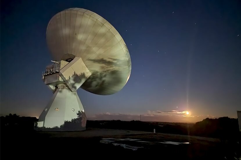
– The GENESIS mission's goal is to do something that has never been accomplished before in satellite and space exploration - emphasises Prof. Krzysztof Sośnica. – This will be the first mission to use not only classic satellite tracking methods based on GPS and Galileo navigation signals. For the first time the satellite will transmit signals at frequencies received by radio telescopes – he adds, and explains that until now radio telescopes had been used to observe extragalactic sources of so-called quasars or the surroundings of black holes using so-called large-baseline interferometry. However, they did not track Earth satellites, because their frequencies were not suited to radio telescopes (e.g. in the case of GPS) or the satellites were moving too fast in relation to stations in low orbits, and the large antennas of radio telescopes were not able to track such fast-moving objects.
Four ways to track satellites
The GENESIS mission will be in medium orbit at an altitude of approx. 6,000 kilometres above the Earth. This will allow it to be tracked simultaneously by several radio telescopes from the Earth's surface, and it will be well below the altitude of the GPS and Galileo navigation satellites to track their microwave signals (the GPS and Galileo navigation satellites – GNSS – are at an altitude of approx. 20 200-23 200 km). In addition, the GENESIS satellite will be tracked by Satellite Laser Ranging (SLR) ground stations, which require the highest level of accuracy.
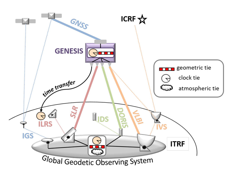
The GENESIS mission concept integrates different measurement techniques on board one satellite
This will ensure that not only microwave but also laser observations are used. A fourth technique that will be used on board will be the tracking of microwave signal frequencies by the GENESIS mission, but not from 'above' as in the case of GPS and Galileo, but from 'below' from so-called DORIS stations – located on the Earth's surface. DORIS enables positioning of satellites based on the so-called Doppler effect, or the frequency shift of the received and transmitted signal due to the relative speed between the transmitter and receiver.
GENESIS will, therefore, be the first satellite mission to be tracked by 4 different observation systems: radio telescopes, DORIS, laser stations, and the mission itself will receive GPS and Galileo signals from satellites above. The combination of techniques used so far relied solely on ground-based measurements between, for example radio telescopes and ground-based GPS receivers, but such measurements were very often inaccurate. The goal of the mission is to reach an accuracy of 1 mm in the performance of the Earth reference system and a change over time of no more than 0.1 mm per year. Such a high degree of accuracy is dictated by the need to monitor climate change in the Earth system with, among other things, the accuracy of observing changes in the height of water levels in the seas and oceans in order to counteract the negative effects of environmental change on society.
GENESIS will solve a number of problems
Currently, inconsistencies between satellite techniques significantly exceed 1 mm, including inconsistencies between navigation systems, laser measurements for satellites, or large-base interferometry. One reason for the inconsistency is the lack of a dedicated satellite mission integrating all four main observation techniques – microwave and laser – on board a single satellite.
A radio telescope for large-baseline interferometry at Yebes Observatory, Spain. Photo: Krzysztof Sośnica
The integration carried out on board the GENESIS satellite will significantly improve the accuracy of the implementation of geodetic reference systems, allow for a better understanding of geodynamic processes, contribute to the accuracy of satellite positioning and navigation, enable satellite time synchronisation free from instrumental errors, and enable scientific research testing relativistic effects as well as a better understanding of processes occurring in the upper layers of the atmosphere and, above all, in the Earth's ionosphere and space weather.
– As stated in the UN resolution 'Global geodetic reference systems for sustainable development': The UN recognises the importance of "Member States' investments in the development of satellite-based positioning and remote sensing of the Earth, supporting a range of scientific endeavours that improve our understanding of the Earth system and support decision making". The GENESIS mission therefore directly responds to the UN's call – emphasises Prof. Krzysztof Sośnica.
The enormous role of the Polish team in the preparation of the mission
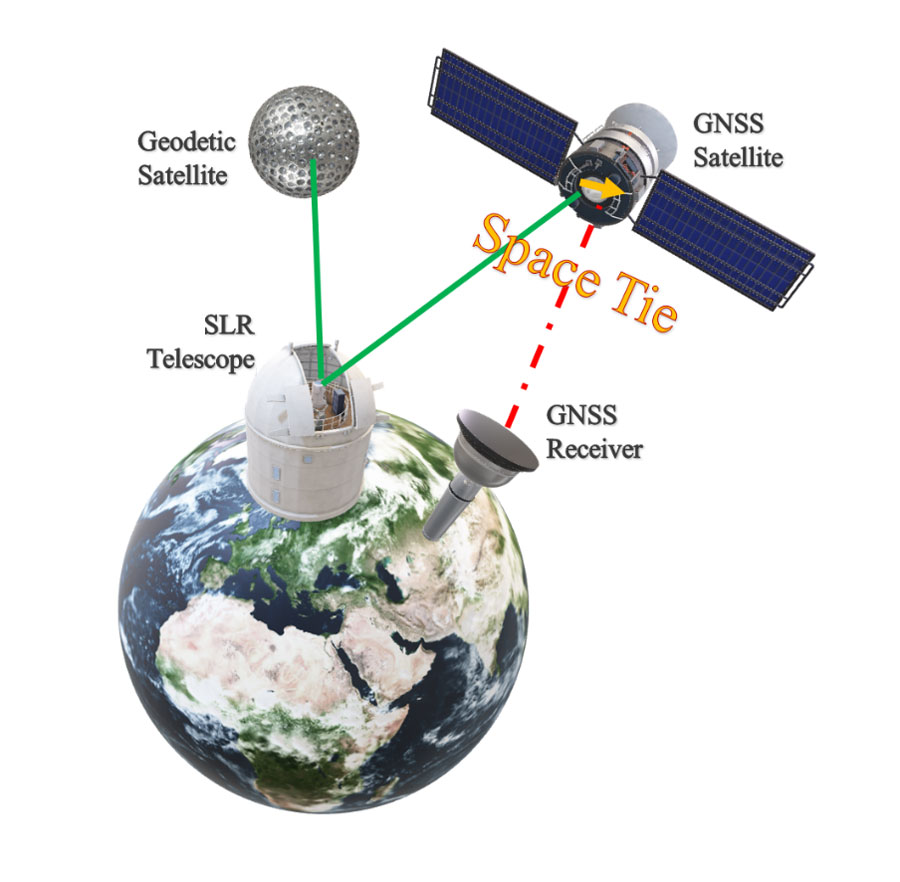
The Polish team has experience in combining various satellite observation techniques, including laser and microwave technology on board Galileo satellites. It was the first team in the world to combine two techniques for improving the orbit of Galileo satellites and develop a methodology for determining the coordinates of stations on Earth with the use of so-called space-ties on board Galileo satellites. In addition, the team was involved in combining GPS and laser observations on low-flying satellites such as SWARM satellites for observing the Earth's magnetic field, GOCE satellites for observing the gravitational field, the Jason-2 and Sentinel-3 satellites for observing sea and ocean levels, and TerraSAR-X for radar observations of Earth surface deformation and building numerical terrain models.
The concept of combining microwave GNSS and laser SLR techniques on board the Galileo
Wrocław is home to the Associated Analysis Centre of the International Laser Ranging Service for Satellites and the Moon (ILRS), which specialises in analysing the accuracy of GPS, GLONASS, Galileo, BeiDou and QZSS microwave orbit measurements and comparing them with laser distance measurements. Among others, the Wrocław centre cooperates with the International GNSS Service in assessing the quality of orbits of GNSS navigation systems satellites based on microwave observations.
The ESA's new mission will be a global geodesy success
The Polish team's experience in combining GNSS and laser techniques on board various satellite missions was an indispensable element that contributed to the excellent preparation of the mission's substantive content. Of the many missions considered by the European Space Agency, only a few percent of the concepts make it to the funding and implementation phase. The GENESIS mission concept, which was prepared, among others, by the Polish team, is therefore an undeniable success, convincing ESA member states to invest financially in the mission as something that will significantly improve the quality of Earth satellite measurements.
The mission is scheduled to be launched into orbit in 2026, with an implementation cost of around €80 million between 2023 and 2026. The overall ESA navigation budget has been increased from €73 million to €351 million since 2019.
The GENESIS mission was developed with the support of the European Space Agency's GNSS Scientific Committee, on which Prof. Paweł Wielgosz of UWM in Olsztyn sits.
Projects of Dr. Karolina Bierowiec, Dr. Agata Mikołajczyk-Martinez, and Prof. Tomasz Hadaś have been awarded in the 13th edition of the National Centre for Research and Development competition, as part of the LIDER programme. The UPWr scientists are to receive nearly PLN 4.5 million for their research.
Dr. Magdalena Domańska, Dr. Karolina Rak, Dr. Magdalena Rychlicka, Dr. Paulina Śliwka, Dr. Agata Wojciechowicz-Budzisz and Prof. Grzegorz Zaleśny have been awarded funding for research projects in the Miniatura 6 competition of the National Science Centre.
This site uses custom cookies to ensure that it functions properly. Some are necessary for the page to run, so will always remain active. These cookies will store information about the user's cookie settings. In addition, third-party cookies are used for external tools. For more information see the privacy policy.
Purpose
Enables storage (such as cookies) related to advertising.
Agreed
Sets consent for sending user data to Google for online advertising purposes.
Agreed
Sets consent for personalized advertising.
Agreed
Enables storage, such as cookies (web) or device identifiers (apps), related to analytics, for example, visit duration.
Agreed
Enables storage that supports the functionality of the website or app, for example, language settings
Agreed
Enables storage related to personalization, for example, video recommendations
Agreed
Enables storage related to security such as authentication functionality, fraud prevention, and other user protection