Satellite remote sensing – joint workshops of the UPWr, the RUS Copernicus and the European Space Agency
Students, PhD candidates and scientists from all over Europe took part in a 5-day on-line workshop "Remote Sensing of Environment" organized by the UPWr and the European Space Agency within the framework of the INCREaSE project.
The first day was for theoretical part including introduction to Earth Observation, introduction to Radar Remote Sensing, Interferometric SAR (InSAR) and Polarimetry. The next four days included four different practical training sessions and exercises related to environmental applications – land subsidence in Mexico City, the earthquake at the Hawaii Island, crop and urban mapping.
Participants of „Remote Sensing of Environment” course accessed a Virtual Machine from their own laptop to exploit the open source toolboxes available in the Research and User Support of ESA environment to download and process Sentinel data.
At the moment of opening the registration, the workshops organized jointly by the UPWr and the European Space Agency were already very popular with satellite geodesy specialists from all over Europe. Eventually, 20 people were selected from the submitted applications - students, PhD candidates, young scientists and industry specialists from Greece, Germany, Great Britain, Austria, Spain and Poland. Due to the pandemic the workshops were held entirely remotely.
One of the participants was Ana-Maria Loghin, who is doing her doctorate at TU Wien. Her research interest is related to very high-resolution satellite observations and stereo reconstruction using these data. She is working in a project that seeks a new applications and processing algorithms for such high-resolution data (such as Planet). She was attending the workshop to better understand the wealth of information that can be retrieved from Sentinel observations. Ana finds especially fascinating the application of SAR in the deformation monitoring, the session on “Land subsidence” was her favorite. She also thinks that the course materials and instructions were super detailed and easy to follow. Ana’s PhD supervisor is prof. Norbert Pfeifer, a internationally renowned scientist working on LiDAR and photogrammetry. Prof. Pfeifer is also one of the UPWr’s partner in H2020 GATHERS project.
Witold Rohm from UPWr
PhD student at National Observatory of Athens Varvara K. Tsironi, aim to integrate GNSS and InSAR observations for seismic inversions – determination of location of epicenter as well as rupture parameters. In her daily work she is using SNAP to process InSAR data and Pyroco to obtain seismic parameters. She was attending the UPWr – RUS-Copernicus course to get new skills in SNAP processing for deformation monitoring, however she found out that other sessions on crop mapping (seismic studies using optical data), urban mapping (use of coherence information) and of course land subsidence was very beneficial. Varvara knows about Wrocław and UPWr from her supervisor prof. dr Athanassios Ganas a lead expert in earthquakes monitoring and predicting at NOA Greece. Prof. Ganas is collaborating with UPWr and specifically with Institute of Geodesy and Geoinformatics on the deformation monitoring and modelling since COST Action 625 “3-D Monitoring of Active Tectonic Structures” 2000-2006. Currently he is member of Advisory Board in H2020 GATHERS project run at UPWr.
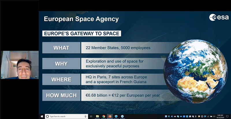
Francesco Sarti from European Space Agency
– The scope of the topics presented during the workshop was closely related with the field of my research carried out as a part the PhD studies. The main goal of my research is integration of InSAR and GNSS methods with particular concern for areas exposed to mining deformations. I was particularly interested in the part of the course related to the analysis of the size of deformations in Mexico City, which are caused by groundwater over-exploitation. The study showed that the maximum subsidence rate in some parts of the city was greater than 30 cm/year. Moreover, in my research, the main goal is to connect the coherence coefficient with the quality of the InSAR time series deformation – said Damian Tondaś, phD student at UPWr. – Thanks to the workshop I learnt how to use the coherence coefficient to automatically detect the urban area using the supervised classification method. Participation in the course conducted by RUS Copernicus organization allowed me to explore my interest from the practical and theoretical aspects. I will certainly use the knowledge that I have acquired in my research.
photo: Shutterstock
The importance of the workshops conducted on the specific example of Mexico City and the contact with experts from the European Space Agency is also indicated by Ewa Knap: – An interesting point of the course was the topic of land subsidence shown on the example of Mexico City, and the great advantage of the whole training was the practical part, during which the course participants could ask questions to experts who clarified their doubts on an ongoing basis. The knowledge I gained from the course will certainly speed up the process of satellite data analysis.
On a daily basis, Ewa Knap uses satellite data in the WATERAGRI project: – In my work, when analyzing radar images, I use the information obtained to determine such data as biophysical parameters of plants (ground biomass, leaf surface index or soil moisture). Using SAR data and optical data, I am able to determine the phenological phase of plants, crop rotation or land use. All the above data is the basis that I use in my work on the WATERAGRI project, the main goal of whichsiis to ensure effective, broadly understood water management, which will allow to reduce pollution and at the same time ensure more sustainable agricultural production.
Workshops are part of the INCREaSE project funded within International Academic Partnership Programme by Polish National Agency for Academic Exchange (NAWA).
This site uses custom cookies to ensure that it functions properly. Some are necessary for the page to run, so will always remain active. These cookies will store information about the user's cookie settings. In addition, third-party cookies are used for external tools. For more information see the privacy policy.
Purpose
Enables storage (such as cookies) related to advertising.
Agreed
Sets consent for sending user data to Google for online advertising purposes.
Agreed
Sets consent for personalized advertising.
Agreed
Enables storage, such as cookies (web) or device identifiers (apps), related to analytics, for example, visit duration.
Agreed
Enables storage that supports the functionality of the website or app, for example, language settings
Agreed
Enables storage related to personalization, for example, video recommendations
Agreed
Enables storage related to security such as authentication functionality, fraud prevention, and other user protection