Wrocław University of Environmental and Life Sciences joins the OGC
Wrocław University of Environmental and Life Sciences is the first university in Poland to become a member of the Open Geospatial Consortium, a global organisation which works on research and promoting geospatial standards.
The OGC is a global community committed to improving access to geospatial and location information. The OCG website says that the organisation is "a worldwide community committed to improving access to geospatial, or location information. We connect people, communities, and technology to solve global challenges and address everyday needs. The organization represents over 500 businesses, government agencies, research organizations, and universities united with a desire to make location information FAIR – Findable, Accessible, Interoperable, and Reusable. Our community creates free, publicly available geospatial standards that enable new technologies. OGC also manages an agile and collaborative research & development process - the OGC Innovation Program - that anticipates and solves real-world geospatial challenges experienced by our members ”.
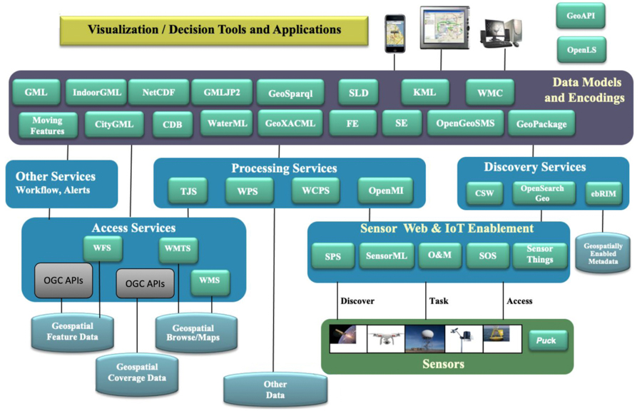
The infographic presents OGC standards photo: OGC
According to Dr. Paweł Bogusławski, the UPWr and OCG collaboration coordinator, from the UPWr Institute of Geodesy and Geoinformatics, being part of the OCG gives access to not only technical information and the opportunity to work in group tasks, but also gives a chance to take part in test projects (OGC testbeds). The OGC testbeds allow standards to be practically verified on real data in real conditions. Wrocław University of Environmental and Life Sciences is the third Polish institution to start working with OGC on a membership basis. Previously only the Polish Geological Institute - National Research Institute and Warsaw City Hall were part of the consortium.
– Exchanging experiences with leading universities in standardizing data and geospatial services, as part of the OGC, opens up new research possibilities as part of inter-university collaborations, and creates possibilities to apply for grants and projects in national and foreign competitions - explains Dr. Bogusławski, and adds that joining the OGC also gives the opportunity to use the latest data in teaching, research projects and as part of diploma or doctoral dissertations.
Geodata is compiled not only from satellite images or point clouds obtained by laser scanning, but also from data collected from various types of devices with a known location. A good example are public buses equipped with a GPS, i.e. a global positioning system, that sends information about the bus’s current position. Another example are weather stations that provide current data from measurement sensors. These type of data-sharing devices are part of the Internet of Things and the different areas of their use make it difficult to use data from various sources in a non-standardized form.
- Standardization enables recording data in widely available formats, and using this data in various systems allows access to useful information - says Dr. Bogusławski. He then lists some areas where the use of geodata is common: flood warning, spatial planning, seismic warning, but also agriculture, where this data is used to control yields, irrigation, disease risk or losses caused by pests or other human or animal activities.
- The possibilities are endless and basically apply to all sectors of the economy. After all, most of us use Google Maps, GPS systems on our phones or navigation systems in our cars. Creating such a global resource would be impossible without automatic data downloads from all over the world, processed in accordance with standards that allow them to be processed and reused - adds Dr. Paweł Bogusławski.
Together with Prof. Witold Rohm, who is responsible for the business coordination of UPWr’s membership in the OGC, Dr. Bogusławski points out that the dynamic development of spatial data formats and services along with the need to exchange them in projects conducted at the Institute of Geodesy and Geoinformatics is what prompted scientists to join the consortium.
- A good example are the EPOS-PL and EPOS-PL + projects, in which data saved in various formats from various sources was processed by an analysis system. The results were saved in standard formats and used by system users for further analysis – explain the scientists from UPWr.
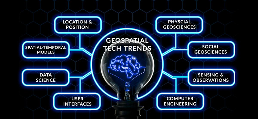
The OGC infographic shows geospatial trends photo: OGC
The Institute of Geodesy and Geoinformatics of Wrocław University of Environmental and Life Sciences for many years has been teaching and researching the topic of broadly understood geospace. Thematic research groups focus on processing large data bases, using artificial intelligence, integrating satellite data and its use in agriculture, and implementing geoinformation network services, and more. This translates into optimising technologies for acquiring, processing and sharing geodata, which requires implementing data exchange standards in carried out projects. The spatial information infrastructure built as part of research and development projects (e.g. the GIS3D platform of the EPOS-PL and EPOS-PL + projects) will enable implementing services and sharing data based on global OGC standards.
Multispectral teledetection from a drone photo: shutterstock
The agreement to join the OGC, was signed in February 2021 by the Rector of Wrocław University of Environmental and Life Sciences, Prof. Jarosław Bosy. – We would like to invite all interested parties to work with us and contact us, by preferably e-mailing the following address: pawel.boguslawski@upwr.edu.pl. The OGC enables exchanging knowledge and experiences between members of the consortium. We have an opportunity to participate in discussions on standards and to take part in thematic groups that deal with agriculture, architecture, power, transport among many other fields - encourages Dr. Paweł Bogusławski, emphasizing that the consortium includes not only universities and research units, but public and local government units and administration too. And one of the goals of the OGC is to establish collaborations and run networking. The OGC gives you a chance to find someone interested in working together, someone who’s offering funds for innovation. This will give you an opportunity to participate in projects financed by various contracting institutions.
This site uses custom cookies to ensure that it functions properly. Some are necessary for the page to run, so will always remain active. These cookies will store information about the user's cookie settings. In addition, third-party cookies are used for external tools. For more information see the privacy policy.
Purpose
Enables storage (such as cookies) related to advertising.
Agreed
Sets consent for sending user data to Google for online advertising purposes.
Agreed
Sets consent for personalized advertising.
Agreed
Enables storage, such as cookies (web) or device identifiers (apps), related to analytics, for example, visit duration.
Agreed
Enables storage that supports the functionality of the website or app, for example, language settings
Agreed
Enables storage related to personalization, for example, video recommendations
Agreed
Enables storage related to security such as authentication functionality, fraud prevention, and other user protection