The most important processes shaping the Earth’s weather and climate takes place in the troposphere. Changes in this, the thinnest layer of the atmosphere, has an impact on the functionality of satellite navigation, the GNSS.
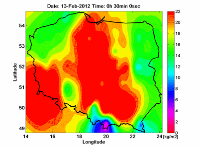
The TOMO2 project, which was created to establish the state of the troposphere in real time, analyses the results of measurements of land and meteorological GNSS stations in order to determine temperatures, pressure and water vapour, between the ground and the troposphere.
The TOMO2 project is run by the Institute of Geodesy and Geoinformatics at the University of Environmental and Life Sciences, and also by Dr. Witold Rohman at the Royal Melbourne Institute of Technology in Melbourne.
Not only does it give us higher accuracy, more stability and reliability when navigating using GNSS devices, it also allows the recording of the real distribution of meteorological parameters in the atmosphere. In other words, it allows the influence of atmospheric conditions during the process of establishing positions using satellite devices to be determined – it shows the vertical profile of the water vapour. It is significant with regard to accurate GNSS positioning and for meteorology. A team supervised by Professor Jarosław Bosy, comprising Dr. Jan Kapłon, MSc Jan Sierny, MSc Tomasz Hadaś and MSc Karina Wilgan, will be responsible for the programme at the University of Environmental and Life Sciences in Wrocław. The purpose of Dr. Rohman's visit in Poland will be to integrate the system modules. “This is operating phase”, says Professor Jarosław Bosy of the Institute of Geodesy and Geoinformatics. “Since the beginning of his work at the University of Environmental and Life Sciences in Wrocław, Dr Witold Rohm has been developing a model of the troposphere's tomography, first in different projects, and then in the PhD. Currently, working at the RMIT in Melbourne as well as in the Australian Bureau of Meteorology, he is gaining experience, which he will use after coming back to Poland”, added Professor Bosy.
The model universality was rigorously evaluated by both the National Science Centre and the National Centre for Research and Development, due to its high implementability – thanks to this, financial support for the project was made possible. Furthermore, the designed model is arousing the curiosity of the Head Office of Geodesy and Cartography. The model is currently used by research teams from the University of Warmia and Mazury and by the Military University of Technology.
This site uses custom cookies to ensure that it functions properly. Some are necessary for the page to run, so will always remain active. These cookies will store information about the user's cookie settings. In addition, third-party cookies are used for external tools. For more information see the privacy policy.
Purpose
Enables storage (such as cookies) related to advertising.
Agreed
Sets consent for sending user data to Google for online advertising purposes.
Agreed
Sets consent for personalized advertising.
Agreed
Enables storage, such as cookies (web) or device identifiers (apps), related to analytics, for example, visit duration.
Agreed
Enables storage that supports the functionality of the website or app, for example, language settings
Agreed
Enables storage related to personalization, for example, video recommendations
Agreed
Enables storage related to security such as authentication functionality, fraud prevention, and other user protection