Having just returned from an internship in Stuttgart and gaining nearly PLN 750,000 funding from the National Science Centre for his project "Simultaneous estimation of the troposphere using the Precise Point Positioning Technique", Professor Tomasz Hadaś will be cooperating on this project with Prof. Thomas Hobiger from the Institute of Navigation at the University of Stuttgart.
Microwave Global Navigation Satellite System (GNSS) signals are delayed in the troposphere. Almost 90% of this delay depends on the atmospheric pressure, which can be determined with high accuracy from numerical weather forecast models. However, the remaining 10%, so-called wet retardation, depends mainly on the water vapour content of the atmosphere, and changes dynamically. Therefore, in GNSS applications requiring the highest precision, e.g. in geodetic surveying and geophysics, the tropospheric wet retardation should be determined together with other unknown parameters, e.g. coordinates or receiver clock correction.
– Simply put, water vapour, which is responsible for the tropospheric wet retardation, slows down and curves the propagation path of the electromagnetic wave sent from the satellite. Failure to take this change into account can result in, for example, a false measurement of the height of a given point – explains Prof. Hadaś, further specifying that the project, which has received funding from the National Science Centre, is innovative and is aimed at shortening and clarifying the currently used procedure for developing GNSS observations.
A project for the curious
Simply put, each ground GNSS receiver, when developing observations, determines the amount of water vapour in the space directly above it – as one value. In the second step this value is converted to water vapour content between the satellites and the receiver. In the third step, i.e. GNSS tomography, the data from the network of earth stations enables recreating the three-dimensional distribution of water vapour. Until now, these three stages have followed one another, and each stage brings with it additional simplifications and limitations. The scientist from the Wrocław University of Environmental and Life Sciences wants to combine them so that the water vapour decomposition is monitored at the stage of developing satellite observations, without determining intermediate products.
Professor Tomasz Hadaś: – This project is an opportunity for meteorology, but also for young researchers interested in science. Photo: Tomasz Lewandowski
– The idea came up during conversations with my tutor during an internship in Stuttgart – at the office, during walks to the cafeteria and when playing badminton. Professor Hobiger was wondering how to simplify this multi-step process, but he did not have the appropriate tools to do so. It turned out that I do. This is a perfect example of complementary competences – laughs Prof. Hadaś, adding that the project, for which he has obtained funding, will be carried out for three years, and includes funding for research conducted by three students, including one doctoral student and one other student for each year, as well as two researchers (for a total of 21 months).
– You could joke that I am announcing a tender for a doctoral student and two other students, with the condition for participation being curiosity about new solutions. But an important element of this project is also cooperation with the University of Stuttgart and Professor Hobiger, which for those passionate about science is an additional advantage – emphasizes Prof. Tomasz Hadaś.
Water vapour, the climate and processors
Tropospheric retardation is recognised as a source of error in GNSS precision positioning, but there are many possibilities for its use in meteorology. Better knowledge of the distribution of water vapour in the atmosphere is valuable information when it comes to climate research, improving the accuracy of weather forecasts or monitoring global warming. Remote monitoring of water vapour content in the atmosphere using GNSS systems, known as GNSS meteorology, has the advantage over classical techniques for measuring water vapour content that it works in all weather conditions and provides a unified product with high spatial and temporal resolution.
In the popular science description of the project by Professor Hadaś submitted to the NSC, apart from information about the dynamic development of GNSS systems, that is the modernisation of existing systems (American GPS and Russian GLONASS) and the construction of new systems (including the European Galileo and Chinese BeiDou), you can also read about the latest achievements in the field of science like multi-core architecture of computer processors and graphic cards that enable the solution of systems of equations, describing the mathematical and physical nature of complex physical problems.
The project will be implemented together with Prof. Thomas Hobiger from the Institute of Navigation at the University of Stuttgart. Photo: Private archive
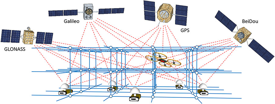
– And this gives us the opportunity to determine the distribution of water vapour in the most consistent manner, through a combination during observation. As part of this project we intend to develop a revolutionary method for determining the distribution of water vapour in time and space (4D), which we call simultaneous estimation of the troposphere using the Precise Point Positioning (STEPPP) technique – explains Prof. Tomasz Hadaś, adding that in his proposed approach the network of fixed (ground) and mobile GNSS receivers will process observations from four GNSS systems based on the precise point positioning technique, in which instead of determining the tropospheric retardation for each station independently, the wet refractivity field will be estimated in a defined space (grid).
25 GNSS receivers in the city
In contrast to GNSS tomography, STEPPP is therefore based on raw observations instead of processed products, and the wet refractivity values at the grid nodes are determined from all stations simultaneously, i.e. they appear as common parameters of a system of equations. Wet refractivity can be converted into water vapour density, resulting in a complete 4D model of water vapour distribution in the atmosphere.
– Our task is to develop a functional and stochastic model for STEPPP, taking into account the variety of observation sources, i.e. mobile and stationary GNSS stations, meteorological sensors, information from numerical weather forecast models, and space-time dependence in the refractive field. We will verify the software and models on the basis of simulated observations, and later on real data. For experiments in the field we will use a dense network of GNSS stations built especially for this project - says Prof. Tomasz Hadaś, adding that the obtained results will be compared with those obtained by traditional methods, i.e. GNSS tomography, GNSS radio-occultations and readings from a microwave radiometer.
Project diagram. Illustration: Tomasz Hadaś
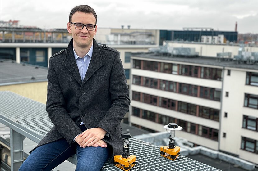
The project will also look into the potential of low-cost GNSS receivers. The scientists will construct 25 such devices and place them across Wrocław. In cooperation with an atmospheric physicist, they will analyse the variability and distribution of water vapour in an as yet unprecedented spatio-temporal resolution during atmospheric phenomena to better understand the physical effects at micro and macro scales.
The project results will stimulate atmospheric research and strengthen the role of GNSS systems as meteorological sensors. The developed approaches and algorithms will be able to be considered as precursors to the implementation phase of the Global Geodetic Observing System (GGOS), which aims to integrate different techniques during the observation phase.
This site uses custom cookies to ensure that it functions properly. Some are necessary for the page to run, so will always remain active. These cookies will store information about the user's cookie settings. In addition, third-party cookies are used for external tools. For more information see the privacy policy.
Purpose
Enables storage (such as cookies) related to advertising.
Agreed
Sets consent for sending user data to Google for online advertising purposes.
Agreed
Sets consent for personalized advertising.
Agreed
Enables storage, such as cookies (web) or device identifiers (apps), related to analytics, for example, visit duration.
Agreed
Enables storage that supports the functionality of the website or app, for example, language settings
Agreed
Enables storage related to personalization, for example, video recommendations
Agreed
Enables storage related to security such as authentication functionality, fraud prevention, and other user protection