Height of mountain peaks in the Tatras to be corrected
Scientists from the UPWr Institute of Geodesy and Geoinformatics carried out precise measurements of the Tatra Mountain peaks. As a result, many atlases and textbooks will have to be revised. Świnica turned out to be one meter higher, the Skrajny Granat on Orla Perć by three meters, and the border post in Rysy stands at 2500 m above sea level.
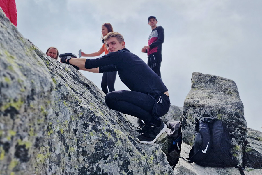
The campaign to measure the peaks in the High and Western Tatra Mountains, conducted by scientists from the Institute of Geodesy and Geoinformatics, UPWr, has ended. In order to take the measurements, they covered a total of over 231 km of trails, climbing a height difference (up and down) equal to 39,963 m, which is more than four times the height of Mount Everest!
The Tatra National Park held a patronage over the measurements and the team comprised of: prof. Krzysztof Sośnica, dr Kamil Kaźmierski, dr Adrian Kaczmarek and Barbara Kubiak, Joanna Najder, Sylwia Porucznik, Dariusz Strugarek, Adrian Nowak, Marcin Mikoś and Filip Gałdyn.
The latest, more accurate measurements are surprising
In most atlases or guides, the height of Świnica is 2301 m. The aerial measurements taken recently indicated that the summit may be slightly higher, but their low accuracy didn’t allow to settle the dispute regarding the correct height. Only satellite measurements using the direct GNSS technique allowed to clearly determine the height of the summit.
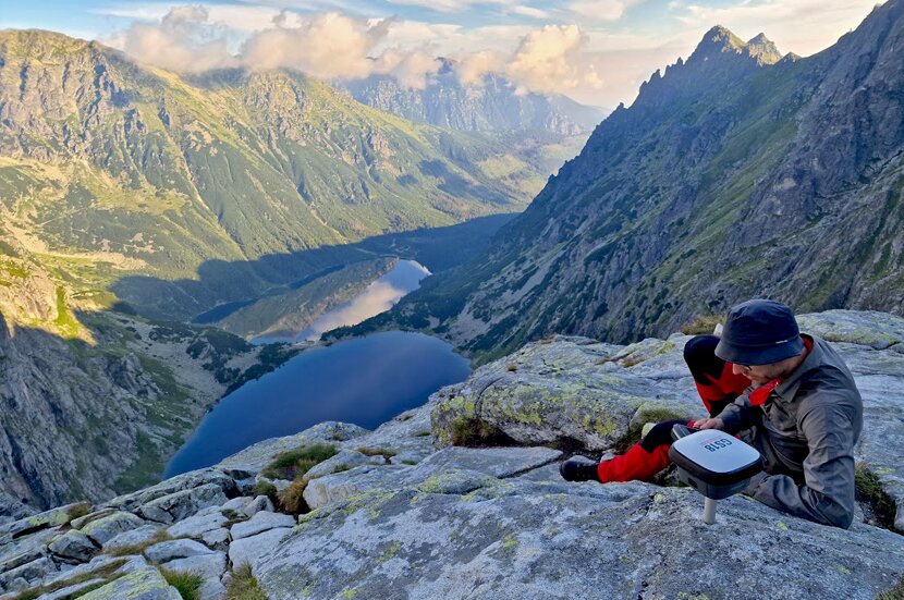
Today we know that the height of Świnica is 2302.36 m, which is over 1 m higher than previously assumed. This is the height of the natural boulder at the top. Slightly below the summit there is a post of the Polish-Slovakian border, 2301.57 m high. Sometimes there are situations where the height of a geodetic point or a pole is given on maps instead of the natural peak. In Świnica, the measurements clearly indicate that the height given in atlases and textbooks should be corrected, as it is 2302 m.
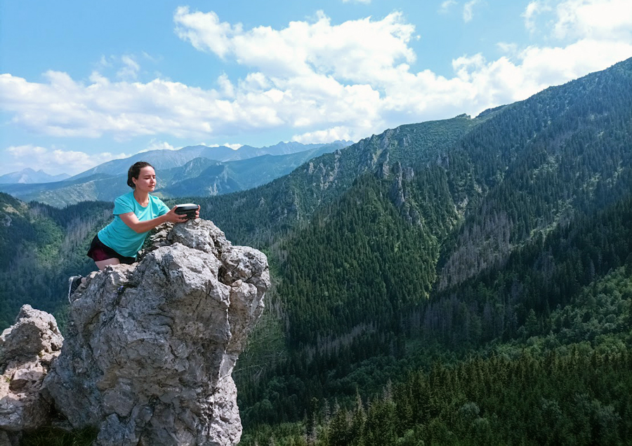
Measurements on Sarnia Skała
Similarly in the case of Rysy. So far, it has been suspected that their height on the Polish side may exceed 2500 m, however, due to the large LIDAR measurement error, it was impossible to decide exactly what the height of the highest mountain in Poland was. Direct measurements made in Rysy during this year's campaign showed that the height of the Polish-Slovakian border post is 2499.71 m, which is 2,500 m when rounded up to full meters.
However, the border post is not a natural object. The height of the highest stable natural rock in Poland is 2499.44 m. So it was not exactly 6 cm high to be rounded up to be able to say that the height of the highest Polish (natural) peak is 2500 m.
The Skrajny Granat on Orla Perć, however, turned out to be higher. So far, it has been assumed that its height was 2225 m. But as it turned out, as a result of careful measurements, the actual height of the Skrajny Granat is 2228.34 m, which is over 3 meters more than previously assumed. On the other hand, the height of Mały Kozi Wierch is “only” 2,225.53 m, and not, as previously thought, 2,228 m. Sarnia Skała also turned out to be nearly a meter higher (1378 m rounded up).
How were the peaks measured and how accurate are the measurements?
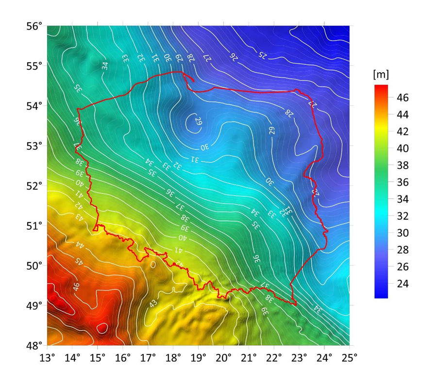
Measurements were made using satellite observations of Global Navigation Satellite Systems (GNSS): GPS, GLONASS, Galileo and BeiDou with the use of precise, multi-frequency geodetic receivers. Measurements were made with the use of corrections generated by the state-run ASG-EUPOS Active Geodetic Network system and real-time network corrections (RTN) based on reference stations in Poland and Slovakia. The ellipsoidal heights have been reduced to the "Amsterdam" altitude system PL-EVRF2007-NH, based on the "Geoid 2021" model. Developed in 2021 (by Prof. Marek Trojanowicz from UPWr with the support of Magdalena Owczarek-Wesołowska), this is the most accurate model to date of the course of the sea level under the surface of Poland.
Geoid model 2021 showing the difference of ellipsoidal heights (measured by GPS) and sea level altitude (normal altitudes) for the territory of Poland
This is the first model that takes into account measurements both in Poland and in neighboring countries, in particular in the Slovakian part of the Tatra Mountains. It was created on the basis of geodetic measurements of height differences, the so-called precise leveling, gravimetric measurements and GPS satellite measurements. In addition, rock density models in the earth's crust up to the crust and mantle boundary were taken into account, as well as numerical terrain models that play a special role in mountainous areas in terms of the computational corrections applied.
The Geoid 2021 model relates its height to the Amsterdam mareograph, i.e. to the North Sea. As a result, Poland became independent from the previously used height system based on a mareograph in the Baltic Sea in Kronstadt near St. Petersburg in Russia. The difference between the heights in the two height systems is from 10 to 22 cm depending on the part of Poland and results from the fact that the "Amsterdam" model is based on newer and more accurate geodetic measurements, including satellite measurements, and moreover, the water table in the Baltic Sea is slightly higher than in the North Sea.
The Kronstadt height system can still be used in Poland, but no longer than until December 31, 2023. After that, only the "Amsterdam" altitude system will apply in Poland, which is similar to many Central and Western European countries. Therefore, the newest and most accurate sea level altitude model for Poland - Geoida 2021 is based solely on the latest altitude system for the North Sea.
The differences between the previous model, which did not take into account data from Slovakia, reach even 40 cm in the vicinity of Zakopane and the Tatra Mountains. Hence, earlier height measurements in this area could have been affected by significant measurement errors when they were performed with GNSS satellite techniques.
Why was it not possible to accurately measure the peaks before?
The peak heights in Poland are given above sea level in the so-called normal height system. Sea level is measured along the coasts using mareographs and then data is averaged over many years. However, determining the height of the points away from the coast is difficult. In order to "drag" the sea level under the continent, geodetic measurements of height differences are necessary together with measurements of the acceleration of the Earth's gravitational field, the so-called gravimetry, because the course of the sea level under the continent depends on the type and density of rocks that make up the Earth's crust, and these affect the acceleration of gravity.
Rysy - measuring the highest peak on the Slovakian side
Without a model of the course of the sea level below the land surface, GPS altitude measurements are useless. GPS gives the altitude in relation to the mathematical surface - an ellipsoid, the course of which can differ by up to 100m in relation to the sea surface, i.e. the geoid. Therefore, the heights determined by GPS satellite techniques should always be reduced by the model of the course of the sea under the continent.
The measurement campaign in the Tatra Mountains was financed from the funds allocated to the Leading Research Team of SpaceOS "Team for observation and research of the Earth using geodetic techniques" financed by the University of Life Sciences in Wrocław as part of the "Initiative of Excellence - Research University" program.
This site uses custom cookies to ensure that it functions properly. Some are necessary for the page to run, so will always remain active. These cookies will store information about the user's cookie settings. In addition, third-party cookies are used for external tools. For more information see the privacy policy.
Purpose
Enables storage (such as cookies) related to advertising.
Agreed
Sets consent for sending user data to Google for online advertising purposes.
Agreed
Sets consent for personalized advertising.
Agreed
Enables storage, such as cookies (web) or device identifiers (apps), related to analytics, for example, visit duration.
Agreed
Enables storage that supports the functionality of the website or app, for example, language settings
Agreed
Enables storage related to personalization, for example, video recommendations
Agreed
Enables storage related to security such as authentication functionality, fraud prevention, and other user protection